Typical Surface Karst Features
Sinkholes & Dolines
- Sinkholes and dolines are both quite common in most karstic terrains, but are not quite as widespread in the Black Hills as in other major karst areas. Nonetheless, they are a locally prominent feature in some of our better explored areas of Karst development.
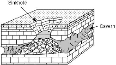
- Sinkholes are steep sided, roughly circular collapse features which often lead directly or indirectly into an underground cavity. The adjacent diagram shows what a fully developed sinkhole collapse looks like.
- Although numerous Black Hills caves have sinkhole entrances, many more are accessed through enlarged solution cavities and fractures exposed in drainages, bluffs and cliffs.
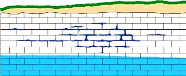
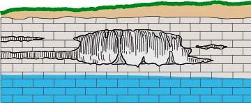
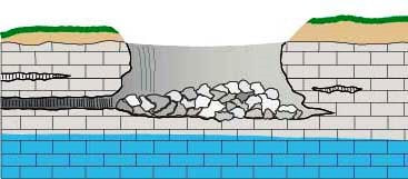
- The following panel of diagrams show the development cycle of a typical sinkhole from incipient dissolution, through cavern enlargement and then through eventual collapse. In the instance shown below, all of the cavern growth takes place in the vadose zone above the water table, which is less common here in the Black Hills than in some other areas.
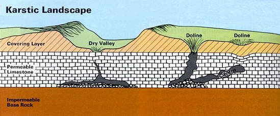
- A doline is a shallow funnel or dish-shaped depression due to the slow dissolution of bedrock where there are intersecting networks of fissures and fractures.
- With time, a doline may develop into a sinkhole, especially where there is a corresponding solution cavity of sufficient size directly below the feature.
- Various dolines are illustrated in the adjacent diagram with the middle feature transitioning into a sinkhole . As has been suggested in the descriptions above, there is a complete continuum between dolines and sinkholes and in some areas, these terms are used interchangeably.
- Some dolines here in the hills contain shallow ephemeral ponds and wetlands that hold rainwater for extended periods until it seeps downwards. There are other examples, however, that remain filled with water and do not dry up. These features are likely spring fed.
- Dry Lake (ephemeral) and Red Lake (perennial) in the northern part of the Black Hills are both examples of dolines but there are many others throughout the region .
Epikarst
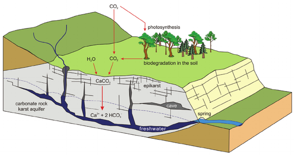
- Epikarst refers to the features found in the upper part of a karst system, in which water is stored and modified before it percolates into underlying aquifers.
- Epikarst includes small solution pockets , minor solution enlarged fractures, small fissures and residual soils that form in and over soluble bedrock.
- These feature capture and hold surface water long enough to allow it to saturate with atmospheric carbon dioxide and the organic acids in the soil, thus forming a more efficient acidic solution for dissolving rocks at depth.
- Physical expressions of epikarst are subtle, but may include spongy appearing outcrop exposures, small divot-like depressions in the soil and faintly elongated fracture and fissure trends in bedrock and within their thin overlying soils.
- The reddish residual soils known as Terra Rosa that form over carbonate bedrocks can also be considered as epikarstic, as they are clay rich and hold water for extended periods of time.
Lapies (Karren) & Grikes
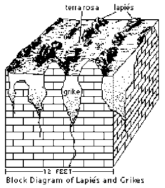
- Lapies (karren) and grikes are near surface features that result from dissolution of soluble limestone and gypsum bedrock along parallel fractures.
- These features are most typically observed in areas with deeply weathered carbonate bedrock. In the Black Hills, these features are more restricted than in other karst terrains, as the climate, on the whole, is semi-arid. On moist north and northeast facing slopes in the higher altitude areas, however, they can be observed.
- The diagram above illustrates the typical geometry and scale of lapies and grikes .
- Grikes are solution widened and clay/debris filled fractures systems found in weathered limestone areas that are separated from one another by narrow ribs of relatively unweathered residual bedrock known as lapies or karren.
- The terms lapies and karren are used interchangeably in most areas, with karren being the German/European equivalent of the other.
- These features often result in a series of low, parallel and closely spaced ribs of rock separated by shallow soil filled depressions. Lapies and grikes can be seen clearly exposed in road cuts in the areas where they occur.
- The reddish, clay rich soil that fill the grikes is known as Terra Rosa. This soil type is a distinctive weathering feature in karst terrains worldwide. It is found in moist areas where outcrops are sparse and weathering has created continuous soil cover over the underlying carbonate rocks.
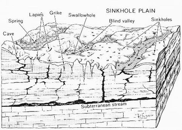
All of the features described above are common in well developed karst terrains.
Many other unusual and characteristic features can also be observed in karst areas. Some of these are shown on the adjacent diagram. They include:
- Stream Sink or Capture Zone - A zone along a drainage where water flow infiltrates into the stream bed over a short distance.
- Swallow Hole - A place where a stream disappears abruptly into a hole or whirlpool.
- Subterranean Stream - Streams found in partially or completely flooded passages that are fed through underground springs and/or from water inflow from the surface.
- Blind Valley - A drainage where the collapse of a cave system has led to a valley shaped depression with no outlet on one end.